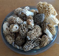
With the snow receding, soil temperatures beginning to rise, and spring on the horizon my mind has been turning to morel mushrooms. Actually, it’s less of a casual thought and more of an obsession.
Over the past couple of years, I’ve returned to Michigan for an annual morel hunt. My homeland may be one of the greatest places to hunt morel mushrooms. The passion for morels is so strong in Michigan, and especially the northern half of the lower peninsula, that people who don’t even like mushrooms go looking for them. I wrote about all of this, and especially the bond morel hunting has forged between my father and me, for Traverse Magazine a few years back.
The thing I found about hunting morel mushrooms in Michigan, versus in the Pacific Northwest, is their terrain choice. If I found morels in abundance in the burns of the Pacific Northwest, I’ve found them more easily among the ash trees in Michigan’s pinky.
Which has led me to start trying to map trees and soil, in hopes that if I know where to find stands of ash—or elm, which they also tend to favor but which blight has pretty much eliminated in Michigan—then maybe I will also find morels there.
So, with that goal in mind, I tromped over to the New York Public Library yesterday to hunt for maps. And boy, did the library deliver. Granted, the maps I found of forest coverage types were a bit dated and a bit hard to see without the help of a magnifying glass, but they gave me a starting point. It’s a working theory for now—both that I can map tree types across the East Coast and that they will lead me to morels—but, it’s one I intend to try to prove, and also document, over the course of this year.
Now, if I can just forage enough patience to get me through to the start of morel season.
